Ctrl+K

Watershed Workflow

  • Introduction
  • Examples
  • Installation
  • Concepts
  • API Documentation
    • Gallery
  • Introduction
  • Examples
  • Installation
  • Concepts
  • API Documentation
  • Gallery
Version v2.0
On this page
  • Indices and tables

Watershed Workflow#

_images/watershed_workflow.png

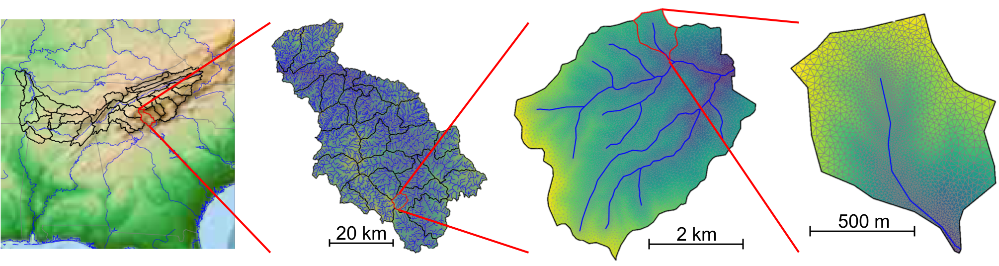
Watershed Workflow is a python-based, open source chain of tools for generating meshes and other data inputs for hyper-resolution hydrology, anywhere in the (conterminous + Alaska?) US.

Browse the code at: environmental-modeling-workflow/watershed-workflow

Contents:

  • Introduction
    • Workflows via Jupyter notebooks
    • Acknowledgements, citation, etc
  • Examples
    • Mixed-element Meshing - Toy Problem
    • Soil Structural Data Comparison
    • AORC Data
    • Working with MODIS for Land Cover and LAI data
    • Mixed-Element Mesh for the Coweeta Watershed
    • Complete Workflow for generating ATS input for Coweeta
  • Installation
    • Summary of Dependencies and their Usage
    • Installation with Docker
    • Local Installation
    • Run the test suite (developers)
  • Concepts
    • Package configuration
    • Coordinate Reference Systems (CRS)
  • API Documentation
    • High Level API
    • Data Sources
    • Geometry and Shape Manipulation
    • Meshes
    • Data Manipulation
    • Utilities
  • Gallery
    • Data Sources

Indices and tables#

  • Index

  • Module Index

  • Search Page

next

Watershed Workflow

© Copyright 2019-202X, UT Battelle, Ethan Coon.

Created using Sphinx 8.2.3.

Built with the PyData Sphinx Theme 0.16.1.